WILLIS'S WALKABOUTS
Bushwalking in the Pilbara
The Pilbara is the region immediately to the west of the Kimberley. It contains some of the most interesting and least known bushwalking
country in Australia. Most of our bushwalking trips take place in Karijini National Park
and the Hamersley Ranges just outside the park.
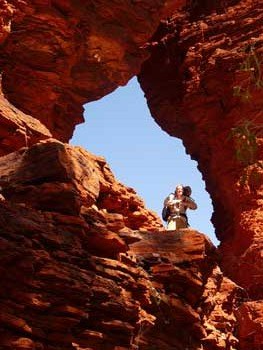
Despite its remoteness, Karijini is well known for its deep, spectacular, red-walled gorges which hide magnificent pools and waterfalls. Fortunately for us, much less well known is the fact that extended bushwalks
are not only possible, but incredibly enjoyable and not too difficult. A hike of less than one kilometre from a tourist track can bring us to a lovely pool we have all to ourselves.
We also sometimes offer treks in the little-known Chichester Range in the Millstream-Chichester National Park. We hike deep into the heart of the range seeking out hidden pools and gorges which will remain forever unknown to non-walkers.
Our April and June-July Pilbara-Karijini tours depart from Tom Price.
If you'd like a better idea what bushwalking in the Pilbara is like, have a look at the galleries on our Karijini trip pages.


Pilbara Links
All our Pilbara trips depart from Tom Price. To get to Tom Price, you need to fly to Paraburdoo and catch a shuttle bus.
The Tom Price Tourist Bureau website
has more information about the town and the area.
- Tom Price Accommodation
- You can download a map of the town and basic maps of other places from their map page.
The Australia's Northwest Pilbara page
has a wealth of information about the region.
The WA Department of Parks and Wildlife has a number of pages which give good information about the area.
- The Karijini National Park page gives a good summary of the park environment.
- The Karijini download page includes links to a park brochure and other brochures abour specific areas.
- The Millstream-Chichester National Park page has good information about that park.
Also worth noting, we visit the Karijini Visitor Centre
on all our Karijini treks.
Neither of the official park pages mentions the possibility of doing overnight hikes. They give no hint as to just how good trekking there can be. Anyone who has ever been on one of our trips can tell you just how big an omission this is.
Weather
The Pilbara climate is similar to, but somewhat warmer than that in the Red Centre. Autumn and winter are the most comfortable times for trekking, so all our trips take place then.
Want more info about the weather?
Try these links from the Bureau of Meteorology. Wittenoom (closed in 2019) was the closest weather station to Karijini. Paraburdoo is slightly higher and further inland. The weather in Karijini is somewhere between the two.
For detailed tables of climate averages, click Wittenoom
or Paraburdoo. For even more information, click "all available" instead of "main statistics" at the top of the tables.
Click here to see a picture of the last three months rainfall in WA. You can change the settings at the top to see different intervals.