Bushwalking in the Kimberley

WILLIS'S WALKABOUTS

Bushwalking in the Kimberley

The Last Frontier

The Kimberley is big. It is larger than the Australian states of Victoria and Tasmania combined, almost as big as Germany, Italy or California in the USA.


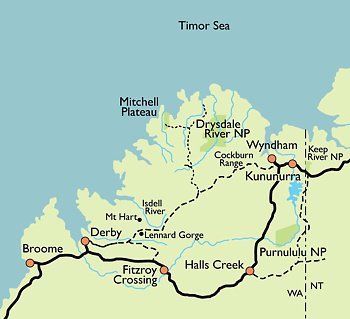
The Kimberley is empty. It is home to less than 40000 people, most of whom are concentrated in a few small communities. Only one sealed road passes through it. Many of the gravel roads are impassable during the wet season. One of these roads, the Gibb River Road, is one of the best known 4WD destinations in Australia.


The Kimberley is spectacular. This is a land of rugged mountains, spectacular waterfalls and mighty rivers that could fill Sydney Harbour in a matter of hours. The Kimberley's incredible cliff-lined coast is one of the most beautiful in the world. As a trekking destination, it is among the best in the world.


The Kimberley is wild, wonderful and full of surprises. It contains an amazing number of Aboriginal rock art sites. There is a variety of vegetation, much relatively unstudied. The animals are less shy and easier to see than in Kakadu. Fishing is excellent.


The Kimberley climate is similar to that in the Top End: a warm, wet season (December-April) when waterfalls appear everywhere and wildflowers carpet the land, a dry season (April-September) when the weather is absolutely perfect and a Build Up (October-December) when it is so hot that we do not offer any treks.


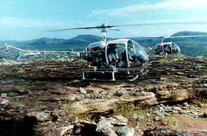
Trekking in the Kimberley.. Unless you are rich enough to pay for a helicopter, the only way to visit most of the Kimberley is on foot, hiking through the wilderness on a bushwalk.

There is no one else!

There are dozens of tour operators who can show you parts of the Kimberley. Willis's Walkabouts is the only one who offers treks where you leave the tracks behind and hike deep into the wilderness on bushwalks to wonderful places which can only be reached on foot.

The Kimberley can't be described in a single page. The Bungle Bungles; the Mitchell Plateau; the Charnley, Drysdale, Durack, Isdell and Ord Rivers; the Carr Boyd, Cockburn and Osmond Ranges - and more. Hiking in every one of these wonderful places needs a page of its own. See Kimberley Areas below or the right hand menu for more information.

All our Kimberley hiking tours depart from Kununurra. There are daily flights to Kununurra from Perth, Broome and Darwin.

More Kimberley information web links

The best single source of information about the Kimberley is the Kimberley Australia Travel Guide website. There is lots of free information plus a book you can purchase and download.  It contains a Kimberley Facts page which has some interesting statistics about the region.


If you are interested in rock art, Rock Art Australia (formerly the Kimberley Society), has a wealth of information. 


Also worth visiting are the official regional tourism sites.

Kimberley Trekking Areas

Much of the Kimberley remains inaccessible by road. We use a combination of chartered helicopters, float planes, light aircraft, boats and 4WD vehicles to provide you with the opportunity to discover and enjoy a variety of the best bushwalking areas in the region. Except where otherwise described in our tour list, our Kimberley treks depart from Kununurra.

No two trips are alike. Some trips trek in a single area; on others others we hike in several. Details are in the tour list. The areas we visit include the following. 
Share by: